Walk from Calvi to Capu di a Veta
An easy 4-hour hike with outstanding views over the Calvi Bay from the famous statue of Notre Dame de la Serra and from the top of Capu di a Veta (703 m) -- the highest hill above Calvi.
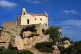 Notre Dame de la Serra above Calvi
- Location
- Balagne region on the western coast of the Northern Corsica (Haute Corse).
- Hike Time and Distance
- About 4 hours roundtrip. 8.8 km (5.5 miles).
- Elevation Gain
- 690 m / 2264 ft
- Difficulty
- Easy walk with few more difficult parts. The trail is marked by orange/red marks.
- Trailhead
- Calvi, south-west of the town centre, at the end of Chemin Donateo.
- Directions
- Calvi is the largest town of Balagne region, directly accessible by ferry and air, by train and bus from Bastia and Ille Rousse, or by car via the N197 road.
- Food and Accommodation
- Many bars, restaurants, hotels and campsites in Calvi.
- Map
- IGN 4149
Map of the trail
The map below shows the basic route in purple with red markers indicating important way points. The blue line shows an alternate descent to the centre of Calvi.
Waypoints
- Trailhead in Calvi
- Notre Dame de la Serra (243 m)
- Capu di a Veta (703 m)
- Centre of Calvi
Last modified on Sun, 2011-05-22 11:26
All texts and images (c) 2006-11 Corsica for Hikers, unless stated otherwise. Contact